google-site-verification: google65a39e745045bc19.html Shocking Facts

Cyclone Phailin hits 90 lakh people; 23 dead, lakhs of homes damaged

 Cyclone Phailin on Sunday left a trail of destruction knocking down lakhs of homes affecting nearly 90 lakh people and destroying paddy crops worth about Rs 2,400 crore, but Odisha and Andhra Pradesh escaped from widespread loss of life.

As the largest evacuation efforts in the country's recent history helped keep casualties to the minimum, reports from the two states tonight said that 23 people died, all but two of them in Odisha. Most of the casualties were caused by wall collapse, uprooted trees and in floods.

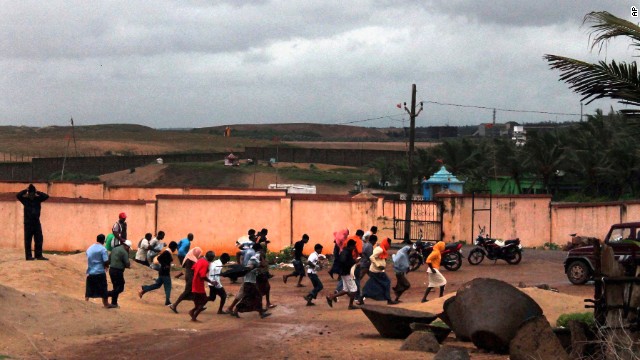
Communication links were vastly disrupted by the strong winds that went upto a speed of 220 kmph when the "very severe" cyclonic storm crossed the coast near Gopalpur last night and weakened before turning into a depression. Ganjam district in Odisha bore the brunt of the storm.

According to IMD tonight, Phailin weakened further turning into "deep depression" with wind speed of 45-55 kmph and currently lay over northern Chhattisgarh, parts of Orissa and Jharkhand. According to M Mohapatra, scientist (Cyclone Warning Division) of the meteorology department, the "cyclonic storm" has now turned to "deep depression" with the wind speed of 45-55 kmph. It currently lays over northern Chhattisgarh, parts of Orissa and Jharkhand. It is expected to weaken further late tonight, he said.


A Panama-registered cargoship M V Bingo carrying iron ore was reported to have sunk in rough seas in the impact of the cyclone off the coast of West Bengal, but the crew were spotted in a lifeboat by a Coast Guard Dornier aircraft.

Authorities in Odisha evacuated nearly nine lakh people, the largest in recent history, ahead of the storm to cyclone shelters and public buildings like schools to avoid a repeat of the monstrous 1999 super cyclone in which nearly 10,000 people were killed.

"We are on the whole quite satisfied with the type of evacuation that was done," Vice chairman of National Disaster Management Authority M Shashidhar Reddy said. In Gopalpur, where the storm struck first, "almost 90-95% people had been evacuated".

Defence and paramilitary personnel were deployed to carry out relief and rehabilitation measures and restoring infrastructure badly affected by the storm.

The IMD earlier in the day said Phailin has weakened into a cyclonic storm with wind speed between 60 and 70 kmph.

Odisha chief minister Naveen Patnaik said the primary aim was to minimize loss of human lives and they have successfully managed to do so. "Property to the tune of several crores has been damaged...Rehabilitation will now be done."

Giving details of the devastation, Odisha revenue minister S N Patro said 14,514 villages in 12 districts have been affected, hitting a population of 80,53,620.

Over 2.34 lakh houses have been damaged and more than 8.73 lakh people evacuated.

Over five lakh hectares of standing crops have been destroyed by the gushing waters causing an estimated loss of Rs 2,400 crore, he said.
Power situation under control: Power ministry

There were some disturbances in electricity transmission due to cyclone Phailin which struck Odisha and Andhra Pradesh last night, but were attended to in time, the power ministry said.

"Required load and generation were managed in a balanced manner so as to secure stable transmission frequency," it said in a statement.

In Andhra Pradesh, the load was reduced to about 9,000 megawatt (MW) against normal demand of 10,000MW and in Odisha, it was 600MW against the normal demand of 2800MW.

Based on IMD information, extensive prior preparations were undertaken to tackle the effects of cyclone Phailin in the context of power requirements," it said.

Advance preparations were made to manage generation and load balance for unhindered and secure grid operation. Power stations in the region were also monitored, it further added.

As required load and generation were managed in a balanced manner so as to secure stable transmission frequency.

Also three Emergency Restoration Systems (ERS) of PGCIL were put on standby readiness in AP and Odisha for quick deployment in the event of damage.

The National Load Dispatch Centre under the control of POSOCO was operating 24 hrs and in touch with the regional dispatch centres of POSOCO and the state load dispatch centre (SLDC).

A high level team headed by additional secretary in the ministry was coordinating all the steps required including 2 hourly reports to all concerned, the statement further added.

Cyclone Phailin kills 14, leaves trail of destruction in India


People run for cover following the cyclone warning at Gopalpur beach in Odisha, India, on October 12.

Hours after it snapped power lines, overturned cars and ripped away bamboo homes, the most powerful cyclone to hit India in years weakened Sunday, but not before it left at least 14 dead. Morning light revealed damage from Tropical Cyclone Phailin after it pounded the eastern coast, the strongest storm in India in 14 years.
Debris littered wet streets. Buildings had gaping holes where roofs and windows had been.

In Odisha state, where the cyclone landed, at least 13 people were killed after trees fell and walls collapsed when the storm hit, Police Chief Prakash Mishra said. Another death was confirmed in Andhra Pradesh state, India's disaster management authority said.Many had feared the death toll would be higher. Massive evacuation efforts helped limit the number of casualties, officials said.

"It is a huge, huge relief," Naveen Patnaik, Odisha's chief minister, told CNN sister network CNN-IBN. "Damage has been minimal." But in the hardest hit areas, the storm's impact was clear, with flooded highways, fallen trees and downed power lines.

As a precautionary measure, authorities cut the electricity in the affected districts. It could take up to a week to restore power, authorities said. Like a fierce hurricane. Hurricanes are known as cyclones in the Indian Ocean. At 140 mph wind speed, Phailin made landfall as the equivalent of a Category 4 hurricane. The trongest hurricane is a Category 5, which comes with winds greater than 155 mph. By Sunday, some 13 hours later, it was the equivalent of a Category 1 hurricane with winds of about 80 mph.Where have all the hurricanes gone?

India evacuated nearly a million people before the storm to avoid a repeat of what happened in 1999, when a cyclone killed 10,000 people.
"We have taken a zero-casualty approach," said Kamal Lochan Mishra, Odisha state's disaster manager. "If people do not move, force will be used to evacuate them."
Phailin has brought nearly 8 inches of rain to Odisha's capital of Bhubaneswar, about 30 miles from the coast. The city's average rainfall for October is 6.5 inches.
The storm will continue to fall apart as it moves over land, but tropical storm-force winds are still possible through early Monday, said CNN meteorologist Judson Jones. Rainfall will also be a problem as Phailin moves up toward the Himalayas in Nepal.

Multiple states in the region were under weather warnings for excessive rainfall and thunderstorms.Hundreds of emergency shelters. About 900,000 were evacuated in Odisha alone. Most people in low-lying coastal areas of the state left on foot or by bicycle, Kamal Lochan Mishra said. Relocating evacuees is a major challenge because of property damage and losses caused by the storm, said Patnaik. Most are housed in nearly 250 emergency shelters set up in sturdy buildings like schools and government offices.

The India Meteorological Department warned of extensive damage to houses made of flimsy materials like mud and bamboo, as well as damage to old buildings. The storm disrupted power and communication lines. Extensive flooding also affected rail and road traffic, and crops are likely to suffer major damage, the agency said.

In Gopalpur, a coastal resort town in Ganjam, restaurants were shuttered and streets deserted. Tourists and local residents left the town. Military deployed In October 1999, Cyclone 05B, also known as the Odisha Cyclone, made landfall in the same area, killing 10,000 people. It was the strongest tropical cyclone recorded in the Bay of Bengal, with winds of 155 mph at landfall. It caused more than $2 billion in damage.

In advance of Phailin, military units and National Disaster Response Force personnel were deployed to coastal areas with relief supplies and medical aid, CNN-IBN said.
All flights to Odisha have been canceled and train services in the state are also disrupted, CNN's sister network reported.
Officials survey damage.

As authorities surveyed the damage Sunday, they said food assistance would be provided to severely impacted villages. Teams from nonprofits were also canvassing the affected areas. Initial surveys indicate the damage was not as bad as many feared it could be, Save the Children said. But strong winds and heavy rains continued to pound some areas. "There may be delays in being able to reach the most vulnerable families with aid," said Devendra Tak, a spokesman for the organization. "This also means it could take some time before the full extent of the damage is known."


How Bad Will Cyclone Phailin Be for India?

Disaster looms for India as ferocious Cyclone Phailin, currently equivalent in strength to a Category 5 hurricane, bears down on the subcontinent ahead of its expected landfall tomorrow night (Oct. 12), local time.

phailin cyclone

Experts say that the enormous and powerful storm, with maximum sustained winds of more than 160 mph (260 km/h), will bring a "catastrophic" storm surge, the water that a storm's winds push in front of it and that inundate a coastline as the storm makes landfall, said Hal Needham, a climatologist at Louisiana State University. The storm surge is expected to reach heights of 20 feet (6 meters), Needham told LiveScience.

The storm is likely to be "as bad or worse" than a cyclone that followed a similar trajectory in 1999, called Odisha cyclone for the area it hit. That storm killed nearly 15,000 people and caused $4.5 billion in damages, said Eric Holthaus, a meteorologist for the online publication Quartz. Phailin (pronounced pie-leen) has now tied the record, with Odisha, for the largest cyclone on record in the Indian Ocean, Holthaus told LiveScience.

While a different rating system is used for cyclones in the Indian Ocean and Bay of Bengal, cyclones are the same phenomenon as the hurricane seen in the Atlantic, where Phailin would be a Category 5 hurricane, the strongest type. According to the U.S. National Weather Service, these types of storms will destroy "a high percentage of framed homes," with "total roof failure and wall collapse. Fallen trees and power poles will isolate residential areas. Power outages will last for weeks to possibly months. Most of the area will be uninhabitable for weeks or months." [A History of Destruction: 8 Great Hurricanes]

How it got so powerful

Cyclone Phailin underwent a period of rapid intensification in the past couple days — and continues to strengthen — for two primary reasons. First of all, ocean surface temperatures in the Bay of Bengal are warmer than 28 degrees Celsius (82.4 degrees Fahrenheit), which is "about as warm as ocean water can get," Holthaus said. Warm temperatures favor intensification, as hurricanes are basically heat engines and are powered by the transfer of heat energy from the water to the upper atmosphere.

Secondly, there have been very light upper winds, and little wind shear, which is a change in direction or strength of winds with increasing altitude, Needham said. When there is too much wind shear, upper-level winds can tear apart developing hurricanes (and that is why there have been few strong Atlantic hurricanes to date this year).These calm conditions allowed Phailin to grow and strengthen, Needham said.Phailin intensified almost as fast as any storm on record, going from the strength of a tropical storm, with wind speeds under 74 mph (119 kph), to the equivalent of a Category 4 hurricane, with wind speeds above 130 mph (209 kph), in the span of 24 hours, Holthaus said. It has also grown to be about half the size of India.

All this is a huge problem for India, and to a lesser extent Bangladesh, with a low-lying and heavily populated coastline, Needham said. The Bay of Bengal is also quite shallow, which means that storm surges tend to get higher because there isn't a well of deep water to deflect energy from the strong winds, he said. The shape of the bay also channels water toward eastern India, making storm surges worse, he added.

Storm surge central

This puts millions of coastal residents in a perilous situation. While hundreds of thousands of people have already evacuated, many more are still at home and are likely to be inundated by the cyclone, Holthaus said.

These facts help explain why the Bay of Bengal, which is a relatively small ocean basin, has experienced approximately 17 of the 23 tropical cyclones that have killed at least 5,000 people in recorded history, Needham said.  

Experts say that Cyclone Phailin is likely to be disastrous. "A Category 5 landfall is bad anywhere, and typically the aftermath is described as 'catastrophic,'" said Brian McNoldy, a researcher at the University of Miami, in an email. "It can't get much worse!"

The height of the expected surge would be comparable to that generated by the Galveston hurricane of 1900, which killed more than 6,000 people and is the deadliest natural disaster in American history, the Washington Post reported.

Cyclone Phailin forces tens of thousands to flee northeast India


Cyclone Phailin, the most powerful storm to take aim at northeastern India since 1999, forced the evacuation of tens of thousands along the Bay of Bengal coastline as it threatened to flood escape routes, disrupt rail service and cut off power for weeks.

Phailin, which means “sapphire” in Thai, has winds of 135 mph and was expected to make landfall about 6 p.m. local time Saturday, according to L.S. Rathore, director-general of the India Meteorological Department. The U.S. Navy’s Joint Typhoon Warning Center in Hawaii estimated Phailin’s top winds at 161 mph, a Category 5 on the U.S. hurricane scale, which is different than the one used by the rest of the world. Hurricane Andrew in 1992, was a Category 5 storm.


“The storm has the potential to cause huge damage,” Rathore said. “We don’t contemplate it will further intensify. It will remain as a very severe cyclonic storm.”

Phailin sent at least 64,000 people fleeing from their homes and forced ships out of its path, and is expected to cause crop and infrastructure damage. Twenty-six of the world’s 35 deadliest tropical cyclones, the storms that include hurricanes and typhoons, have occurred in the Bay of Bengal, according to Jeff Masters, founder of Weather Underground in Ann Arbor, Mich.

“It’s going to cause pretty complete devastation on the coast where it hits,” Masters said by telephone. The storm weakened slightly as it grew larger but had begun to strengthen again. Masters said it was likely that Phailin would lose some strength before going ashore, probably in the Odisha region, as the equivalent of a Category 4 storm, the second-strongest on the five-step Saffir-Simpson Scale.

Andrew, which hit southern Florida, had top winds of 174 mph and was a 150 mph storm when it made landfall, according to AccuWeather in State College, Pa.

Paradip Port Trust, India’s biggest dry bulk cargo facility, sent all its ships to sea and shut down operations, spokesman Prakash Chandra Mishra said by phone. The National Disaster Management Authority dispatched a 1,500-person rescue force to Odisha and Andhra Pradesh states, while the Indian air force said it sent two IL-76 airlift teams and was committing two C-130J Super Hercules planes.

Andhra Pradesh’s chief minister, Kiran Kumar Reddy, urged citizens in low-lying areas to move to safer ground.

“We are prepared for the worst,” Pradipta Kumar Mohapatra, special relief commissioner of Odisha, said by phone from the state capital of Bhubaneswar.


Cyclone energy? Equal to 100 H-bombs

A tropical cyclone can be compared to a heat engine. The energy input is from warm water and humid air over tropical oceans. Release of heat is through condensation of water vapour to water droplets/rain.
Only a small percentage (3%) of this released energy is converted into kinetic energy to maintain cyclone circulation (windfield).
A mature cyclone releases energy equivalent to that of 100 hydrogen bombs.
phailin cyclone
What may be the wind speed in most severe storm?
The wind speed may be as high as 300 kmph.
What is the wind speed at the center of a storm? What is weather there like?
Nearly calm wind with fair weather prevails at the center of the storm.
Which sector of the cyclone experiences strongest winds?
In general, the strongest winds in a cyclone are found on the right side of the storm. The "right side of the storm" is defined with respect to the storm's motion: if the cyclone is moving to the west, the right side would be to the north of the storm; if the cyclone is moving to the north, the right side would be to the east of the storm, etc.
The strongest wind on the right side of the storm is mainly due to the fact that the motion of the cyclone also contributes to its swirling winds.
A cyclone with a 145 kmph winds while stationary would have winds up to 160 kmph on the right side and only 130 kmph on the left side if it began moving (any direction) at 16 kmph. While writing the cyclone warning bulletins, this asymmetry is taken into consideration.
For tropical cyclones in the southern hemisphere, these differences are reversed: the strongest winds are on the left side of the storm. This is because the winds swirl clockwise south of the equator in tropical cyclones.
What is the damage potential of a super cyclonic storm 120 Knots (222 Kmph) & above? What are the suggested actions?
Structures: Extensive damage to non-concrete residential and industrial building. Structural damage to concrete structures. Air, full of large projectiles.
Communication and power: Uprooting of power and communication poles. Total disruption of communication and power supply.
Road/Rail: Extensive damage to kutcha roads and some damage to poorly repaired pucca roads. Large scale submerging of coastal roads due to flooding and sea water inundation. Total disruption of railway and road traffic due to major damages to bridges, signals and railway tracks. Washing away of rail / road links at several places.
Agriculture: Total destruction of standing crop / orchards, uprooting of large trees and blowing away of palm and coconut crowns, stripping of tree barks.
Marine Interests: Phenomenal seas with wave heights more than 14 m tall. All shipping activity unsafe.
Coastal Zone: Extensive damage to port installations. Storm surge more than 5 m, Inundation up to 40 km in specific areas and extensive beach erosion. All ships torn from their moorings. Flooding ofescape routes.
Overall Damage Category: Catastrophic
Suggested Actions: Fishermen not to venture into sea. Large-scale evacuations needed. Total stoppage of rail and road traffic needed in vulnerable areas.
Why are tropical cyclones named?
Tropical cyclones are named to provide easy communication between forecasters and the general public regarding forecasts, watches, and warnings. Since the storms can often last a week or longer and that more than one can be occurring in the same basin at the same time, names can reduce the confusion about what storm is being described.
The first use of a proper name for a tropical cyclone was by an Australian forecaster early in the 20th century. He gave tropical cyclone names "after political figures whom he disliked.
During World War II, tropical cyclones were informally given women's names by US Army Air Corp and Navy meteorologists (after their girlfriends or wives) who were monitoring and forecasting tropical cyclones over the Pacific.
From 1950 to 1952, tropical cyclones of the North Atlantic Ocean were identified by the phonetic alphabet (Able-Baker-Charlie-etc.), but in 1953 the US Weather Bureau switched to women's names. In 1979, the WMO and the US National Weather Service (NWS) switched to a list of names that also included men's names.
Read more

Mass evacuations as 'Super Cyclone' Phailin hits India

System expected to be fiercest to threaten country since a storm that killed 10,000 in 1999

A woman carries her baby as she moves to a safer place with others at the village Donkuru in Srikakulam district in the southern Indian state of Andhra Pradesh Oct. 12, 2013. Rain and wind lashed India's east coast on Saturday, forcing more than 400,000 people to flee to storm shelters as one of the country's largest cyclones closed in, threatening to cut a wide swathe of devastation through farmland and fishing hamlets


phailin cyclone


Strong winds and heavy rains pounded India's eastern coastline Saturday, as authorities rushed to move tens of thousands of people away from massive Cyclone Phailin, which is expected to be the fiercest cyclone to threaten the country since a storm killed 10,000 people 14 years ago.
The skies were dark – almost black – at midmorning in Bhubaneshwar, the capital of Orissa state and about 60 miles from the coast. Roaring winds made palm trees sway wildly, and to the south, seawater was pushing inland.

Cyclone-India
Satellite images showed the system covering an area roughly half the size of India. Some forecasters have likened its size and intensity to that of Katrina, which blasted the U.S. Gulf Coast in 2005.
If the storm continues on its current path without weakening, it is expected to cause large-scale power and communications outages and shut down road and rail links, officials said. There could also be extensive damage to crops.
While there is some disagreement about how strong the storm's winds will be, the India Meteorological Department (IMD) warned that Phailin, which is expected to hit the coast by Saturday evening, is a "very severe cyclonic storm" that will bring with it maximum sustained winds of 130 to 135 mph. The IMD also predicted flooding and storm surges of about 10 feet above normal tides. 
Some foreign forecasters have suggested that India's weather office is underestimating the power of Phailin, which means "sapphire" in Thai.

The storm has strengthened at one of the highest rates ever recorded, going from a tropical storm to a category 4 cyclone in only 24 hours. On Friday (Oct. 11), became the equivalent of the catagory upto 5 hurricans - the strongest on the American scale—with sustained winds of 160 mph (260 kph). That official wind speed has tied Phailin with the devastating 1999 Orissa Cyclone which killed more than 10,000 people—currently India’s strongest storm ever. Cyclones in India are the same as hurricanes in the United States — different words for the same thing.
+

At least one atmospheric scientist believes a catastrophic storm surge—the rise of ocean levels pushed by a storm’s winds and pressure—may be a certainity. Storm surge is by far Phailin’s biggest threat to lives along India’s coastline. Ocean levels may rise as much as 6 meters (20 feet) near and to the northeast of the storm’s landfall location, pushing an inexorable wall of water inland. Storm surge of nearly 3 meters may stretch as far northeast as the vulnerable Ganges Delta of Bangladesh—home to tens of millions. The JTWC estimates that waves of up to 17 meters (56 feet) are already buffeting the Bay of Bengal.
The storm may also bring nearly one meter of extra rainfall to inland areas that have already borne the brunt of an overly active monsoon season.+
And the storm may not be finished strengthening yet.
Phailin is now forecast to break the Indian Ocean intensity record set by the 1999 Cyclone just prior to its Saturday landfall, according to the US Navy’s Joint Typhoon Warning Center (JTWC) in Pearl Harbor, Hawaii:io0213 (4)
Even if Phailin doesn’t manage to hold the intensity record, the storm surge will be immense. An American specialist, Hal Needham, wrote that recent research shows that the strength of a storm 18 hours before landfall is the best predictor of its peak storm surge. In India and Bangladesh, where so many live only a few meters above sea level, the sheer size of Phailin nearly guarantees that hundreds of thousands of homes will be inundated. A storm surge of 1 to 3 meters could extend for hundreds of kilometers northeast of where the storm makes landfall. In short, Phailin is a humanitarian disaster in the making.
+

Despite international consensus that Phailin was among the most powerful storms ever to threaten the subcontinent, India’s Meteorology Department (IMD) continued to gauge the storm’s strength conservatively. In the latest forecast, the IMD predicted sustained winds of 210-220 kph and storm surge of up to 3.5 meters (11 feet) at landfall. These numbers are about 40 kph weaker than the JTWC’s most recent forecast, and in my opinion, the storm surge could be double what IMD is predicting.
One possible explanation for this discrepancy is a different philiosphy of interpreting satellite data.

Other weather centers predicted stronger winds. The U.S. Navy's Joint Typhoon Warning Center forecast gusts of up to 196 mph. The London-based storm tracking service Tropical Storm Risk said Phailin was a Category 5 "super cyclone," evoking memories of the 1999 storm in Odisha, when winds reached speeds of 186 mph and battered the state for 30 hours.
Winds reached 140 mph during Hurricane Katrina in Aug. 2005.
This time Odisha's state government said it was better prepared. It broadcast cyclone warnings through loudspeakers and on radio and television as the first winds were felt on the coast and in Bhubaneswar.
Large waves were already pounding beaches in the neighboring state of Andhra Pradesh. Villagers were evacuated to schools in the north of the state, while panic buying drove up food prices. 
By Friday evening, some 420,000 people had been moved to higher ground or shelters in Orissa, and 100,000 more in neighboring Andhra Pradesh, Indian Home Secretary Anil Goswami told The Associated Press.
Not everybody was willing to leave homes and belongings, and some villagers on the Andhra Pradesh coast said they had not been told to evacuate.
"Of course I'm scared, but where will I move with my family?" asked Kuramayya, a fisherman from the village of Bandharuvanipeta, close to where the storm is expected to make landfall. "We can't leave our boats behind." 
Officials cancelled celebrations for the Hindu holiday of Durga Puja – a celebration of the Hindu goddess Durga – and stockpiled emergency supplies in coastal Odisha and Andhra Pradesh states.

Cyclone Phailin is set to become the strongest India has ever seen


With landfall in less than 24 hours (Saturday Oct. 12 in the afternoon, India time), final preparations are underway in India for Cyclone Phailin—now officially the strongest storm ever measured in the Indian Ocean. The image above shows the storm’s core as it approaches the coastline. (See our earlier coverage on why Phailin’s landfall in this particularly volatile part of India is especially unwelcome.)

+
At least one atmospheric scientist believes a catastrophic storm surge—the rise of ocean levels pushed by a storm’s winds and pressure—a certainity. Storm surge is by far Phailin’s biggest threat to lives along India’s coastline. Ocean levels may rise as much as 6 meters (20 feet) near and to the northeast of the storm’s landfall location, pushing an inexorable wall of water inland. Storm surge of nearly 3 meters may stretch as far northeast as the vulnerable Ganges Delta of Bangladesh—home to tens of millions. The JTWC estimates that waves of up to 17 meters (56 feet) are already buffeting the Bay of Bengal.
The storm may also bring extra rainfall to inland areas that have already borne the brunt of an overly active monsoon season.
And the storm may not be finished strengthening yet.
Phailin is now forecast to break the Indian Ocean intensity record set by the 1999 Cyclone just prior to its Saturday landfall, according to the US Navy’s Joint Typhoon Warning Center (JTWC) in Pearl Harbor, Hawaii.+
Despite international consensus that Phailin was among the most powerful storms ever to threaten the subcontinent, India’s Meteorology Department (IMD) continued to gauge the storm’s strength conservatively. In its forecast, the IMD predicted sustained winds of 210-220 kph and storm surge of up to 3.5 meters (11 feet) at landfall. These numbers are about 40 kph weaker than the JTWC’s most recent forecast, and in my opinion, the storm surge could be double what IMD is predicting.


+

+
This is the view from India’s Kalpana weather satellite:
latest_kalpana_ir2_fd


The storm has strengthened at one of the fastest rates ever recorded, going from a tropical storm to a category 4 cyclone in only 24 hours. On Friday (Oct. 11), it became equivalent of a catagory of 5 hurricans -  the strongest on the American scale—with sustained winds of 160 mph (260 kph). That official wind speed has tied Phailin with the devastating 1999 Orissa Cyclone which killed more than 10,000 people—currently India’s strongest storm ever. Cyclones in India are the same as hurricanes in the United States — different words for the same thing.
At least one atmospheric scientist believes a catastrophic storm surge—the rise of ocean levels pushed by a storm’s winds and pressure—may now be a certainity. Storm surge is by far Phailin’s biggest threat to lives along India’s coastline. Ocean levels may rise as much as 6 meters (20 feet) near and to the northeast of the storm’s landfall location, pushing an inexorable wall of water inland. Storm surge of nearly 3 meters may stretch as far northeast as the vulnerable Ganges Delta of Bangladesh—home to tens of millions. The JTWC estimates that waves of up to 17 meters (56 feet) are already buffeting the Bay of Bengal.
The storm may also bring nearly one meter of addition rainfall to inland areas that have already borne the brunt of an overly active monsoon season.
And the storm may not be finished strengthening yet. Read more.

Live: Cyclone Phailin made landfall at about 5.40pm says American meteorologist

The storm over east central Bay of Bengal moved westwards, slightly intensified further and lay centred about 590 km south-southeast of Paradip in Jagatsinghpur district and 600 km southeast of Gopalpur in Ganjam district, SC Sahu, director of Bhubaneswar meteorological centre said.phailin cyclone
*The cyclone has made its landfall in Andhra Pradesh, and the eye of the storm is expected to hit Odisha, according to US government website National Environmental Satellite Data and Information Service.
*There are conflicting reports about whether Phailin has made a landfall, with the IMD reportedly telling a BBC journalist that it is still an hour away.
*At least three people have lost their lives so far. Two were killed by falling trees while a third died when the walls of her mud house collapsed, according to Reuters.
"Cyclone Phailin has made landfall near Srikakulam, Andhra Pradesh," says  Eric Holthaus, lead Meteorologist & Weather Editor for the WeatherMob app. "The strongest winds, rain, & surge will be felt NE," he says. Landfall...confirmed by at least one satellite estimate. It occurred near Kapaskuddi, Andhra Pradesh, India, according to him.
* Arrangement of food, drinking water, medical facilities, relief and rescue operation at stations has been made by East Coast Railway, under whose jurisdiction the area that Cyclone Phailin is expected to hit falls. 
For drinking water Sintex water tanks of 2000 litre capacity have been made available and six  BTPN wagons with water have been positioned at Palasa. Read More
* TV reports suggest Cyclone Phailin is 80 kilometres away from the coast of Andhra Pradesh and it will hit the coast at a speed of 230 kilometres per hour.
* Around 445,000 people have been evacuated from the coastal areas of Odisha and Andhra Pradesh where the cyclonic storm Phailin will make landfall Saturday evening, the National Disaster Management Authority (NDMA) said. 
* Odisha Chief Minister Naveen Patnaik on Saturday said all necessary steps have been taken to evacuate people from low-lying areas, and added that relief, medical and food facilities would be supplied to people affected by Cyclone Phailin. Read more
List of trains that are cancelled or diverted due to cyclone Phailin.
* One of the biggest cyclones in 14 years, cyclone Phailin is expected to cause maximum damage to the Ganjam district of Odisha. About 40% of the relief and rescue teams will be stationed at Ganjam
* Additional information about the monstrous cyclone.
* Rain and wind batter Indian coast as 'super cyclone' barrels down. 
* Andhra Pradesh Chief Minister N Kiran Kumar Reddy  takes stock of cyclone situation; officials on alert Hyderabad. 
* Jharkhand government alerts districts as Cyclone Phailin approaches Ranchi. 
*Cyclone Phailin is rapidly appraoaching the coast of Odisha, just 180km away.
* Twitter India creates a list of 'Citizens, journalists and agencies tweeting about #CyclonePhailin from Odisha and Andhra Pradesh.

*Local Cautionary Signal Number Three (LC-III) has been replaced by Great Danger Signal Number Ten (GD-X) at Gopalpur and Puri Ports and Great Danger Signal Number Nine (GD-IX) at Paradip and Chandbali Ports. 
* According to latest reports, the cyclone is 200 km off the Gopalpur coast which will be the centre of the cyclonic system. 
* Roaring winds and heavy rains lashed coastal Odisha and Andhra Pradesh as cyclonic storm Phailin kept advancing from the Bay of Bengal to hit the coast by Saturday evening. 
* Impact of cyclone Phailin to last for 24 hours, reports the Met department.
*Odisha evacuates 2.5 lakh people as cyclone Phailin approaches Bhubaneswar. 
*India on red alert as mosnstrous cyclone nears east coast
*Phailin to be one of the strongest cyclones to hit India. 
*Google's Person Finder for Phailin goes 
*As many as 52,000 locals were today evacuated and 25,000 people accommodated in cyclone shelters in Srikakulam district in view of cyclcone Phailin which is expected to cross the shore by this evening. .
* As Cyclone Phailin hits Odisha coast, potatoes sell at Rs50 per kg and box of candles at Rs90.
*Heavy rain lash Odisha as cyclone Phailin advances. 
*Cyclonic storm Phailin approaching Odisha, Andhra coasts. 
* Key senior officials of the Government of India are reportedly attending a meeting in the Home Ministry to review the state of preparedness for countering the after effects of Cyclone Phailin. .
* Odisha sets up control rooms to make information available. 
The Meteorological department said Phailin lays centered 450 km southeast of Paradip, likely to make landfall near Gopalpur in Ganjam district tomorrow
* According to Rev minister SN Patro 44,000 people in Puri, 22,430 in Ganjam, 24,900 in J'singhpur, 4,000 in K'para were evacuated to safer places 
*The "very severe" storm Phailin is unlikely to turn into a "super cyclone" like the one which hit the coastal areas of Odisha and Andhra Pradesh in 1999, the MET department said on Friday.
* West Bengal takes steps to manage aftermath of Cyclone Phailin. 
12 IAF helicopters will arrive in state tomorrow, says special relief commissioner PK Mohapatra. 300 Army jawans, 50 doctors from Navy and 29 rescue teams will arrive in state tomorrow, he added. Evacuation of 6 lakh people from 7 districts is going on. Cooked food will be provided from tonight, says special relief commissioner PK Mohapatra.
ECoR cancels 24 passenger trains for Saturday due to cyclone Phailin
* A bulletin issued by  Indian Meteorological Department gave the following advice:
Fishermen out at sea along north Andhra Pradesh, Odisha and West Bengal coast are advised to return to coast. Fishermen are advised not to venture into sea. Total suspension of fishing operations. Mobilise evacuation from coastal areas. Judicious regulation of rail and road traffic. People in affected areas to remain indoors during cyclone landfall.
* Odisha chief minister calls for calm
“I’d request everyone to not panic.. Please assist the government. Everyone from the block to the state HQ have been put on alert. The Navy and the Air Force have been informed and they will help with relief operations,” Patnaik said.
Evacuation process begins in Andhra, Odisha
According to reports, National Disaster Response Force (NDRF) teams have reachedBhubaneswar and evacuation has begun in Odisha and north Andhra Pradesh.
As many as 64,000 people in the north coastal districts of Srikakulam, Vizianagaram, Visakhapatnam in Andhra Pradesh are being evacuated to safer places as 'super cyclone' Phailinis expected to hit the Bay of Bengal coast between Srikakulam and Gopalpur in Odisha by Saturday evening. 
Defence Minister AK Antony asks armed forces to be ready to move in to Odisha and AndhraPradesh in view of cyclone Phailin.


High alert in Odisha as cyclone Phailin intensifies

After remaining stationary for several hours over the sea, the huge cyclonic storm phailin, on Thursday intensified, moving slightly northwest and lay centered at about 850 km southeast of Paradip.
The system was also located 900 km east south-east of Kalingapatnam and 950 km east-southeast of Visakhapatnam, according to the latest IMD bulletin.
The Odisha govt cancelled Dusshera holidays of employees in 14 districts with CM Naveen Patnaik asking collectors to ensure the safety of the people.
"The system would intensify into a severe cyclonic storm during the next 12 hours. It would continue to move northwestwards and cross the north of Andhra Pradesh and Odisha coast between Kalingapatnam and Paradip by night of October 12 as a very severe cyclonic storm with a maximum sustained wind speed of 175-185 kmph," it said.
Under its influence, Odisha would have extreme to very heavy rainfall in many areas during in the next 24 hours.
Distant Warning Signal Number Two (DW-II) kept hoisted at Paradip and Gopalpur ports. Squally weather will prevail along and off Odisha coast after 12 hours.
Fishermen in the deep sea had been asked to return to the coast immediately. The sea would be rough to very rough after 12 hours, it said.
With this monstrous cyclone moving towards the state's coast, Odisha government issued a high alert and cancelled Dusshera holidays of employees in 14 districts with Chief Minister Naveen Patnaik asking collectors to ensure the safety of the people.
The alert was issued in Balasore, Bhadrak, Mayurbhanj, Keonjhar,Dhenkanal, Jajpur, Cuttack, Kendrapara, Jagatsinghpur, Puri, Khurda,Nayagarh, Ganjam and Gajapati districts.
Revenue & Disaster Management Minister Surjya Narayan Patro appealed to the people not to panic over the situation as the government had taken all precautionary steps.
Earlier, the state government had asked the Union Home Ministry to keep helicopters ready for rescue and relief operations.
Special Relief Commissioner P K Mohapatra said the authorities were asked to stock food and relief materials at cyclone shelters.
All district collectors have been provided satellite phones so that they could remain in touch with the government, he said, adding mobile service providers were asked to ensure that towers are repaired immediately in case of damage. Please click here to read more
Please share your views or comments in the box provided below:
 

Text